
Every year, the Northern Hemisphere region of the Atlantic Ocean embraces the annual hurricane season that officially starts on June 1 and ends on November 30. This period has been adopted by convention; it’s when most tropical cyclogenesis occurs in the Atlantic. Though the formation of subtropical or tropical cyclones is possible at any time of the year, as was the case this past mid-January, we witnessed the formation of an unnamed subtropical storm, marking the earliest start of an Atlantic hurricane season since Hurricane Alex in 2016.
Prediction on how active the 2023 Atlantic Hurricane Season (AHS) would be started in December 2022. The 2023 AHS is well on its way, with three named storms formed in June, tying the record for the most to develop in June. Among those storms were tropical storms Bret and Cindy, which formed within a few days of each other, making this month the first June in which two systems were active simultaneously since 1968.
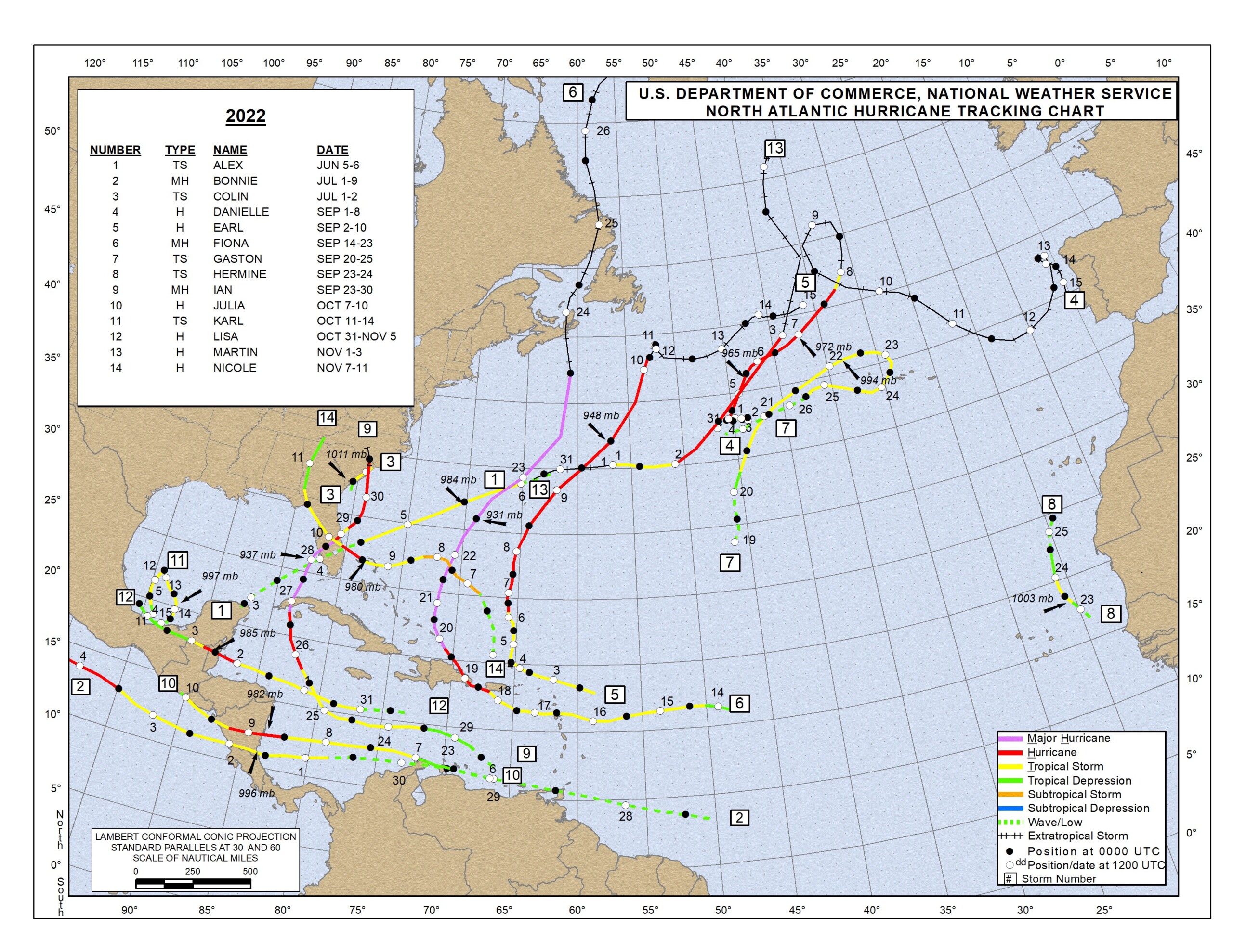
This map shows the tracks, names and start dates of all tropical cyclones in the 2022 Atlantic hurricane season. (Source: NOAA)
Before we continue talking about the 2023 AHS and go over the prediction for this season, it is important to give a quick summary of the 2022 AHS. Although it was characterized as an average AHS with 14 named storms, eight of them strengthening into a hurricane and two reaching major hurricane intensity, the 2022 AHS became the third costliest AHS on record, behind only 2017 and 2005. It was mostly due to Hurricane Ian, which made landfall in southwestern Florida as a Category 4 intensity (on the Saffir-Simpson Hurricane Wind Scale), producing catastrophic storm surge, damaging winds, and historic freshwater flooding across much of central and northern Florida. With over 150 direct and indirect deaths and over $112 billion in damage, Hurricane Ian is the costliest hurricane in Florida’s history and the third costliest in United States history.
Predictors of NOAA’s Climate Prediction Center “predict a near-normal hurricane activity in the Atlantic this year and “a 40% chance of a near-normal season, a 30% chance of an above-normal season, and a 30% chance of a below-normal season.” Furthermore, NOAA has a 70% confidence that AHS is expected to have 12 to 17 total named storms (winds of 39 mph or higher). Of those predicted storms, five to nine could become hurricanes (winds of 74 mph or higher), including one to four major hurricanes (Category 3, 4, or 5, with winds of 111 mph or higher).

Ali Fares, Ph.D.
As we experienced last season, a normal or below-normal hurricane season does not translate into low or average impacts of AHS on the number of human casualties or cost of damages. As detailed above, the 2022 AHS had only a serious hurricane, Ian, which caused widespread devastation and upended lives. Consequently, it is important to remind the public that regardless of the intensity of AHS, we must remind alert and prepared for the eventuality of experiencing a tropical storm. Although coastal areas are more vulnerable to tropical storms, large areas further inland have been severally impacted by hurricanes over the years. As such, we need to be ready.
There are ample resources available from disaster-related agencies at the local, state, and federal levels. The Federal Emergency Management Agency, FEMA, has an App that can be easily downloaded from their website, ready.gov or listo.gov. The sites have adequate resources and information on readiness resources and how to get real-time emergency alerts. The Texas Division of Emergency Management coordinates with state and local governments to help lessen the impact of emergencies and disasters. Visit its website to get more information about it, tdem.texas.gov. Also, the Texas General Land Office website, recovery.texas.gov/preparedness, has additional information on disaster preparedness.
We must remember that getting ready for these storms starts now.
Ali Fares, Ph.D., is the Endowed Professor of Water Security & Water-Energy-Food Nexus at Prairie View A&M University.