
Courtesy: @USCGHeartland on X
Between July 4 and 7, 2025, the Texas Hill Country experienced a sudden and destructive flood that rivaled the devastation of many hurricanes despite being triggered not by a landfalling storm, but by the remnants of Tropical Storm Barry. In hours, rainfall exceeding 11 inches fell over the region, causing the Guadalupe River to surge more than 26 feet in just 45 minutes. As of July 9, over 111 people were killed, including at least 27 children, 180 were missing, and entire communities were left devastated. For residents of towns like Hunt, Kerrville, and Comfort, the flood came not as a forecast but as a shock, many with no warning system in place and little time to act.
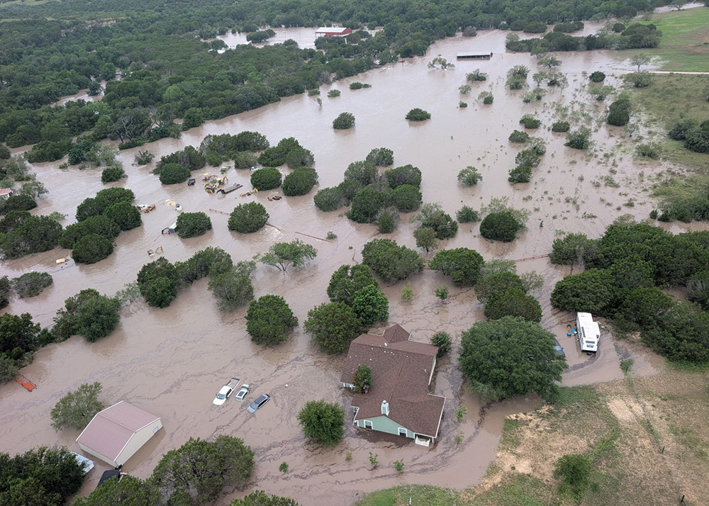
The storm system that followed Barry stalled over Central Texas, forming a mesoscale convective complex that dumped unprecedented rainfall into steep, runoff-prone watersheds. The National Weather Service issued flash flood emergencies, but many alerts arrived late. The U.S. Geological Survey reported record-setting river flows, and in some areas, stream gauges failed due to the sheer volume and speed of water. The economic toll surpassed $18 billion, including widespread damage to homes, infrastructure, agriculture, and small businesses. Schools and local governments faced weeks of closure and months of recovery. This disaster underscored the intensity of inland flooding and the vulnerability of areas often overlooked in hurricane-centered emergency planning. A striking U.S. Coast Guard aerial photo, taken during a rescue operation in Kerr County, captured the severity of the event: submerged roads, flooded rooftops, and families being hoisted to safety amid a vast, muddy expanse of water. The image has since become emblematic of the devastation and the heroism witnessed during the flood response.
As a scientist and educator, I see the 2025 Hill Country Flood not as an anomaly but as part of a troubling trend: the intensification of extreme rainfall events in non-coastal regions, exacerbated by climate extremes, urban expansion, and inadequate preparedness. The flood was a tragedy, but also a clarion call to action.
Texas has taken a critical step forward by releasing the Texas Flood Plan, a statewide blueprint for improving flood preparedness and resilience. What distinguishes this plan is its focus on localized risk mapping, targeted funding for rural and small communities, and non-structural, affordable mitigation strategies. It promotes regional collaboration and provides the tools for counties like Kerr and Comal to finally install the early warning systems they’ve lacked for decades. The plan represents a vision for stronger infrastructure and smarter, more inclusive science-based decision-making.
Our research at Prairie View A&M University (PVAMU) reflects this mission. I’ve had the privilege of working with Dr. Samuel Brody, Director of the Institute for a Disaster Resilient Texas at Texas A&M University at Galveston, on a project focused on flood trends in the Navasota River Basin. Dr. Brody was Principal Investigator for the Navasota River Flooding Project, funded by the Texas A&M University System. Our analysis of the basin’s long-term precipitation and streamflow records revealed an unmistakable trend: increasing rainfall intensities and rising peak flows compounded by urbanization, land-use change, debris blockages, and straightening of the river over time.
These patterns make flash floods more frequent, severe, and unpredictable. We are thankful for the scientific contribution of Dr. Marouane Temimi to this analysis, whose expertise in hydrometeorology and rainfall modeling provided valuable insight into the spatial and temporal characteristics of precipitation trends influencing flood risk in the region. A manuscript reporting on these findings will be published soon.
But while long-term trend analysis is critical, it’s not enough. To prevent tragedies like the 2025 flood, we need tools that extend warning time from minutes to life-saving action. That’s why my team and I have also been exploring ultra-short-term rainfall forecasting, or nowcasting, in collaboration with experts like Dr. Temimi of the Stevens Institute of Technology. His team recently deployed a radar system that overlooks the Hudson River and covers the Manhattan, NY district. It can predict rainfall with 2–3-minute lead times, a breakthrough in flash flood response. If such a system were installed at PVAMU’s elevated site, The Hill, it could be the backbone of an early warning network for the Greater Houston Area, a region increasingly vulnerable to sudden, high-impact storms.
This approach bridges the gap between research and response, technology, and trust. We must develop systems that forecast accurately and reach the people who need them in languages they understand and formats they can act upon. It’s not enough to build more innovative models; we must embed them into the real-world decisions of farmers, families, and first responders.

Ali Fares, Ph.D.
The 2025 Hill Country Flood should not be remembered solely as a disaster. It must be recognized as a turning point when science, policy, and the public align to reshape the future of flood resilience. Through collaboration within Texas and beyond, and by grounding our work in practical application and fairness, we can ensure that when the next storm comes, and it will, we are ready, not surprised.
Because in this new climate reality, science isn’t just knowledge. It’s protection. It’s preparedness. It’s power, and every second truly counts.
Dr. Ali Fares is a Regents Professor, Texas A&M University System, Endowed Professor of Water Security and Water-Energy-Food Nexus, Prairie View A&M University, Editor, Extreme Events and Climate Change (Elsevier).