
Goals and Objectives
Goals
The main goals of the center are:
- To collect data from space through NASA and transfers it to a database system. This information serves as a tool for predicting environmental changes in the region and for producing methodology for risk assessment of the ecosystems;
- To study the water stress in the field crops and to build a spectral library of the agricultural crops using GER Radiometer or ASD Field Spec Radiometer by collecting ground truth data from actual crops. With the capabilities of IDL-ENVI software, the center now has developed its own spectral library for crops. The center is moving forward and using the remote sensing data in detecting the environmental problems in the Gulf of Mexico specially studying the Sea Surface Temperature (SST) of the Gulf to detect its impact on the biological activities.
 |
 |
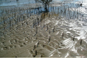 |
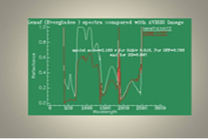
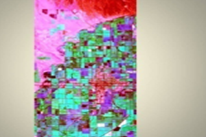
Samples of Ecological studies Related to Remote Sensing and Research in Brackish water
Objectives:
The objectives of the center are:
- To integrate past, ongoing and future environmental quality data. The TEXGED center has constituted a major planning and decision making tool to meet the initiatives of preserving the natural ecosystems and major habitats along the Texas Gulf Coast and its extensions around the neighboring states. Through quick and computer enhanced visualization modeling and interfacing with Geographic Information Systems enhanced access to environmental quality data will decrease the degree of risk involved in diagnostic and analysis which will increase the integrity of the collected data;
- TEXGED Center will be accessible to interested / involved agencies within the state and its design and implementation will address compatibility with similar ongoing efforts within other states along the Gulf Coast assuring the possibility of sharing gathered information;
- The TEXGED Center will enrich the state with knowledge regarding environmental problems as alteration and loss of habitats, introduced species, water pollution, water supply, air pollution flooding and hurricanes, global climatic changes and its impact on the region, ozone layers thinning, radiation, solid wastes, soil systems and its contamination, and finally degradation and loss of open spaces, parks and forests. This enrichment will serve as a tool for predicting the environmentally related changes in the region and will produce methodology or risk assessment of the ecosystems.