
December 2 – Dr. Ram Ray had the opportunity to use satellite images to retrieve soil moisture from the topsoil surface at agricultural land. Along with his colleagues Drs. Kishan Singh and Sudhir Singh, this team of researchers focused on investigating the methods to estimate soil moisture using satellite images (e.g., Landsat and Sentinel-1), models (e.g., Water Cloud, Modified Dubis, and TOPP Models) and in situ measurements. Their findings have made significant contributions to the water resources, hydrology, and remote sensing communities along with the Remote Sensing Journal.
Abstract
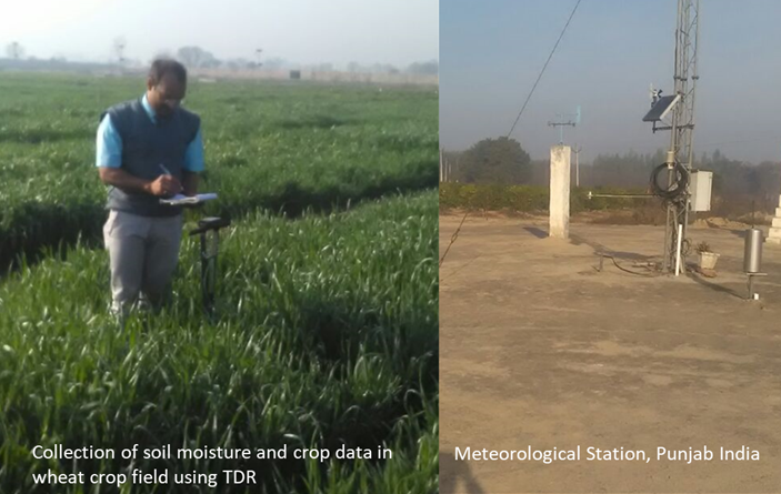
Accurate estimation of soil moisture at high spatiotemporal resolution is needed for a variety of applications. Sentinel-1 and Landsat-8 data were used to retrieve soil moisture from topsoil surface (0–5 cm depth) at agricultural land (area under wheat crop). After pre-processing of satellite data and removal of vegetation influence (σ°veg) using Water Cloud Model (WCM), total backscattering coefficient (σ°total) and Normalized Difference Vegetation Index (NDVI) were used to simulate backscattering from soil (σ°soil). Modified Dubois Model (MDM) and Topp’s Model were used to retrieve soil moisture using ε. Further, modeled soil moisture was evaluated using in situ soil moisture measurements and a Time Domain Reflectometer during Sentinel-1 overpass (24 January, 25 February, and 13 March 2018). Statistical tests showed that an integrated approach has the potential to improve soil moisture estimates over the vegetated/cropped area for agricultural and hydrological studies.
To read the entire article on Dr. Ray’s research, please visit https://www.tandfonline.com/doi/full/10.1080/10106049.2019.1678674

Ram Ray Ph.D., P.E.
Research Scientist
raray@pvamu.edu
(936) 261-5094